| |
Geomagnetism |
|
| Home | Magnetic Field Overview | Model and software downloads | Online Calculators | Magnetic Data Sources | Geomagnetic Tutorials |
|---|
|
|||
|
|||
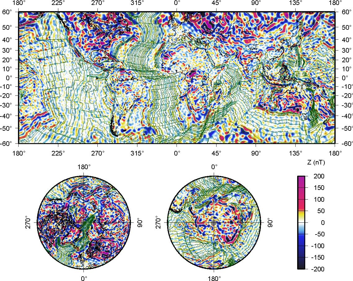
Fig.1: (click to enlarge) Fig. 1: Vertical component of the MF7 crustal magnetic field at the Earth surface, overlain with the isochrons of an ocean-age model inferred from independent marine and aeromagnetic data by Muller et al. (2007) and plate boundaries by Bird (2003). |
|||
| Available MF7 Downloads | ||||||
|---|---|---|---|---|---|---|
| Type | Format | Mbyte | Ref. Radius | Contents | ||
|
|
SH coefficients | ASCII Table | 0.3 | 6371.2 km |
MF7
Model spherical harmonic coefficients (Schmid semi-normalized, as usual) |
|
|
|
Graphic | 1.0 | WGS84 | Image of vertical component (Z) at WGS84 ellipsoid altitude. | ||
|
|
Listing | GZ | 42 | WGS84 |
MF7_Z_0.xyz.gz 6 arc minute ascii grid of vertical component (Z) at WGS84 ellipsoid altitude. |
|
|
|
Graphic | 1.0 | WGS84 | Image of the anomaly of total intensity at WGS84 ellipsoid altitude. | ||
|
|
Listing | GZ | 42 | WGS84 |
MF7_dF_0.xyz.gz 6 arc minute ascii grid of the anomaly of total intensity at WGS84 ellipsoid altitude. |
|
|
|
Listing | GZ | 660 | WGS84 |
MF7_dF_2.5.xyz.gz 1.5 arc minute ascii grid of the anomaly of total intensity at 2.5 km altitude above the WGS84 ellipsoid. This grid is intended for use in the World Digital Magnetic Anomaly Map project for the 2011 revision. Please be aware of the large file size (660 MB) of this grid. |
|
|
|
Graphic | 1.0 | WGS84 | Image of the analytic signal at WGS84 ellipsoid altitude. | ||
|
|
Listing | GZ | 6 | 6771.2 km |
MF7_0_as.xyz.gz Ascii grid of the analytic signal at WGS84 ellipsoid altitude. |
|
|
|
Listing | GZ | 6 | 6771.2 km |
MF7_0_dFdx.xyz.gz Ascii grid of the northward derivative of the total intensity anomaly at WGS84 ellipsoid altitude. |
|
|
|
Listing | GZ | 6 | 6771.2 km |
MF7_0_dF_dy.xyz.gz Ascii grid of the eastward derivative of the total intensity anomaly at WGS84 ellipsoid altitude. |
|
|
|
Listing | GZ | 6 | 6771.2 km |
MF7_0_dFdz.xyz.gz Ascii grid of the downward derivative of the total intensity anomaly at WGS84 ellipsoid altitude. |
|
2010-Aug-19, Stefan Maus